 |
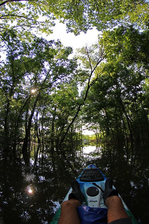
| Kayaking the tree canopy in the 20 foot deep water of Dallas Great Trinity Forest |
The easy to photograph shots of a flooded Trinity River made a splash on the
evening news or social media feeds where a 100 yard walk down the levee
from parking lots at Trinity Groves affords the hallmark postcard shots residents have not seen in years. For many, it is the first time they are discovering that Dallas is a city built upon the banks of a river. The Trinity.
Usually seen as an economic divide, a barrier that separates the haves and the have nots, the river is often more of an untangible figment of human imagination. Few ever see it as a big river with plans of it's own.
 |
| Time exposure of water coursing over the submerged Skyline Trail creating an interesting nocturnal effect on the water |
 |
| A dwarfed Old Red Courthouse standing among buildings 100 years junior |
So long has it been
since the Trinity flooded that Twittering was something only birds did
and instagram was something people would probably associate with a
Western Union wire transfer.
The Margaret Hunt Hill Bridge designed by
Santiago Calatrava had yet to open. It was that long ago.

It is beyond the neon lights of the city, down the river, past the channeled and bastardized levee protection where the river is turned loose and allowed to run wild. Down in the wilderness of the Great Trinity Forest.
It is here, where few ever walk, much less paddle. A place so quiet that one can hear their own heartbeat and the fluttering feathers of a bird in flight. That quiet. Inside Loop 12. A flooded expanse of riverbottom that is completely submerged with no dry ground as far as the eye can see. An area so large that both Dallas bedroom communities of Highland Park and University Park would fit inside of it with room to spare.
Paddling from Pleasant Grove to Joppa and back
 |
| A flooded fifteen acre wildflower field behind Big Spring under 12 feet of water. Looking north. |
The novelty of paddling from Pleasant Grove to Joppa has always been on a
bucket list of sorts. The ease of crossing flooded timber and venturing
into areas which are usually impassable swamp. The high water makes the
usually treacherous terrain of traversing the woods a breeze. If you know where to go. It is the river in the raw. The beautiful waterscape of flooding areas. Coupled with the redeeming quality of time that begins a healing process from sustained drought.
 |
| Paddling across the ONCOR right of way from Big Spring towards Joppa |
 |
| Floating the flooded timber of the Great Trinity Forest with a brief opening in the treeline exposing Downtown Dallas some three miles distant |
 |
| With Sean Fitzgerald and Dallas Police at Joppa during Tropical Storm Bill checking out the immense flooding |
 |
| Texas Task Force One recovering boats at Loop 12, Joppa Preserve |
It seemed necessary to wait till the water receded completely before posting such photos. The water looks placid and calm to a novice. The reality is a dangerous mix of currents, uneven flows and unknown obstructions. With the endless drumbeat of news stories featuring kayak deaths on the Trinity in 2015.

The Trinity even in normal flow conditions can bark and bite with a full set of teeth. During high flows those teeth turn into venom filled fangs that rival western drainage whitewater features. High water renders the Trinity Trail bridge over the river near the Audubon Center into a death trap. Any bridge, column or benign obstruction become a vortex of eddies and whirlpools.
 |
| Loop 12 Boat Ramp turns dangerous with currents that would kill the strongest of swimmers |
There are places in the Great Trinity Forest where no man has ever
walked or visited. Impossible to say such a thing inside Loop 12 but it
is true. Places where the water is just deep enough not to float a boat
but too deep to wade. A flood changes that.
 |
| The historic Bur Oak at Big Spring with a blanket of winecups in the foreground serves as launching point across to Joppa |
Launching from the 900 block of Pemberton Hill Road in Pleasant Grove off Lake June the transect across the Great Trinity Forest is a straightforward affair to Joppa. Unless one wants to wander into the unexplored.
Bryan's Slough
 |
| Up Bryan's Slough...with a paddle |
One such unexplored and never photographed spot are the deep twists and bends of Bryan's Slough, also called Oak Creek. I suppose no one has ever quite decided where the name changes, perhaps US 175 is a good line of delineation. The slough is named for the John Neely Bryan family who once lived on the property. John Neely Bryan is regarded as the founder of Dallas.
 |
| Bryan's Slough, flooded. Narrow snaking passageways through acres of native hibiscus |
In normal river conditions, access to the dense hibiscus groves on Bryan's Slough would be a hip deep slog through prime snake habitat. Conditions that make it impassable even to the most determined. During high water the paddle is still a tad difficult but affords a view or two that no one has ever seen. The sights here resemble that of mangrove swamp. Densely packed plants with narrowing channels and a labyrinth of plant built cul-de-sacs of dead ends.
 |
| Great Blue Heron with a water moccasin snake |
The water in some areas in this section are still shallow enough to support the long legged Great Blue Heron. Seen above, surprised after being spotted by an unexpected kayak rounding the bend. Had the camera not been in a dry bag, the whole spectacle of coup de gras on the snake would have been captured.
In coming weeks this area will bloom into early morning brilliance with saucer sized white flowers of the native Halberdleaf hibiscus. The water loving plants put on a show that no human ever sees. A place remarkable for stunning beauty that no person will ever see.
Rochester Park
 |
| The endless Ash trees that are flooded as one approaches the river channel |
Ash is the dominant species of tree in Rochester Park, Lower White Rock Creek and in areas earmarked for mitigation in the Great Trinity Forest. The photo above is in a planted mitigation area under 6 or seven feet of water. Drowned under all that water are hundreds of planted seedlings of various species from trees to understory plants. Should be interesting to see if any survive inundation for such a prolonged period.
 |
| Making a wake paddling the Lower Chain of Wetlands across an epic tropical sky |
Cumulus clouds begin to build to the west and the south after crossing the river channel. Into the wetland cells where the trees have been cleared to allow for something the Corps of Engineers calls "conveyance". A popular term entering the vocabulary of many this year. The word takes on a sinister meaning for some, as a large piece of riverbottom is clearcut for a pedestrian bridge. Over a quarter mile's worth of trees.
The Flood At Joppa
It
is a few miles downstream of Downtown that one finds the small
community of Joppa. A place forgotten and cast aside by a hundred and a
half years of less than stellar support by the city that annexed the
Freedman's Community. The lack of infrastructure, lack of public
services make Joppa a place with a lot left to be desired. But they sit
on high ground and no home in the near sesquicentennial of the community
has ever seen flood water.
It is below Joppa, where the
city and Corps of Engineers funded the DFE Project known as the Lower
Chain of Wetlands. A place that will never carry the eponymous designation of the community next to it. A series of ponds pumped with treated sewage during
the dry weather is overbanked by the Trinity during times of flooding
rain. The swales or cells have concrete gate structures on the
downstream end that regulate flow and water height during dry spells.
 |
| The rip rap road structure a top the earthen dam between Cell F and G and Joppa |
Dry land at last, some two miles across the Great Trinity Forest one finds first exposed land at the earthen dam bunkering Cell G in the Lower Chain of Wetlands. In the photo above, a thundershower cracks the evening sky over Fair Park and South Dallas. The thunderclaps in the humid air brings concussion with it. Loud reverberating across the near featureless submerged plain.
 |
| A Snowy Egret awaits wayward fish to spill across the dam between Cell F and G in the Great Trinity Forest |

It does not take astute powers of observation to understand the power of water at work. The once tidy and utilitarian weirs and concrete have been altered by a touch of nature in all the flooding. Billions of gallons of water on their way to the Gulf of Mexico pass over this spot carving and weaving man's work into something else.
The damage to such places is hard to know. Even as the flood waters recede and the silt begins to harden into a near cement the tally in what man has built in the floodplain will be a hard price tag to determine. The Trinity River to some took on a larger-than-life appearance for a month. One that some downplay. To others it is a wakeup call that the Trinity is capable of prowess that humans have little control over. Things such as this ponder the mind as one paddles back across the river from Joppa to Pleasant Grove. In the muting light float of a fading summer's night it makes even those who think they know the river change their opinion on the place.


 It is beyond the neon lights of the city, down the river, past the channeled and bastardized levee protection where the river is turned loose and allowed to run wild. Down in the wilderness of the Great Trinity Forest.


 It does not take astute powers of observation to understand the power of water at work. The once tidy and utilitarian weirs and concrete have been altered by a touch of nature in all the flooding. Billions of gallons of water on their way to the Gulf of Mexico pass over this spot carving and weaving man's work into something else.