Thursday, April 19, 2012

What About That Mess At McCommas Bluff


Bumblebee on Foxglove at McCommas Bluff
By any measure, it has been a rough eight months for what many consider to be the only natural crown jewel of the Trinity River in Dallas, McCommas Bluff. A postcard picturesque chunk of hill country real estate sitting in the middle of what is otherwise a muddy river bottom. Fossilized sea creatures the size of hubcaps line the rock. Wildflowers grow on the cliff tops. Coyote calls echo off the bluffs almost every evening. A timeless scene that is quickly vanishing.

It started back last summer when Dallas Water Utilities began a pipeline reinforcement project for a 72 inch water main that meanders along the river. I have said in the past that you have to break some eggs to make an omelette. I'm not an engineer, hydrologist, pipeline expert or claim to be one. I do know a mess when I see one. It's apparent now that this whole foray into messing with the river is getting into the realm of the absurd. I believe the dawn of something stupid is on the horizon.

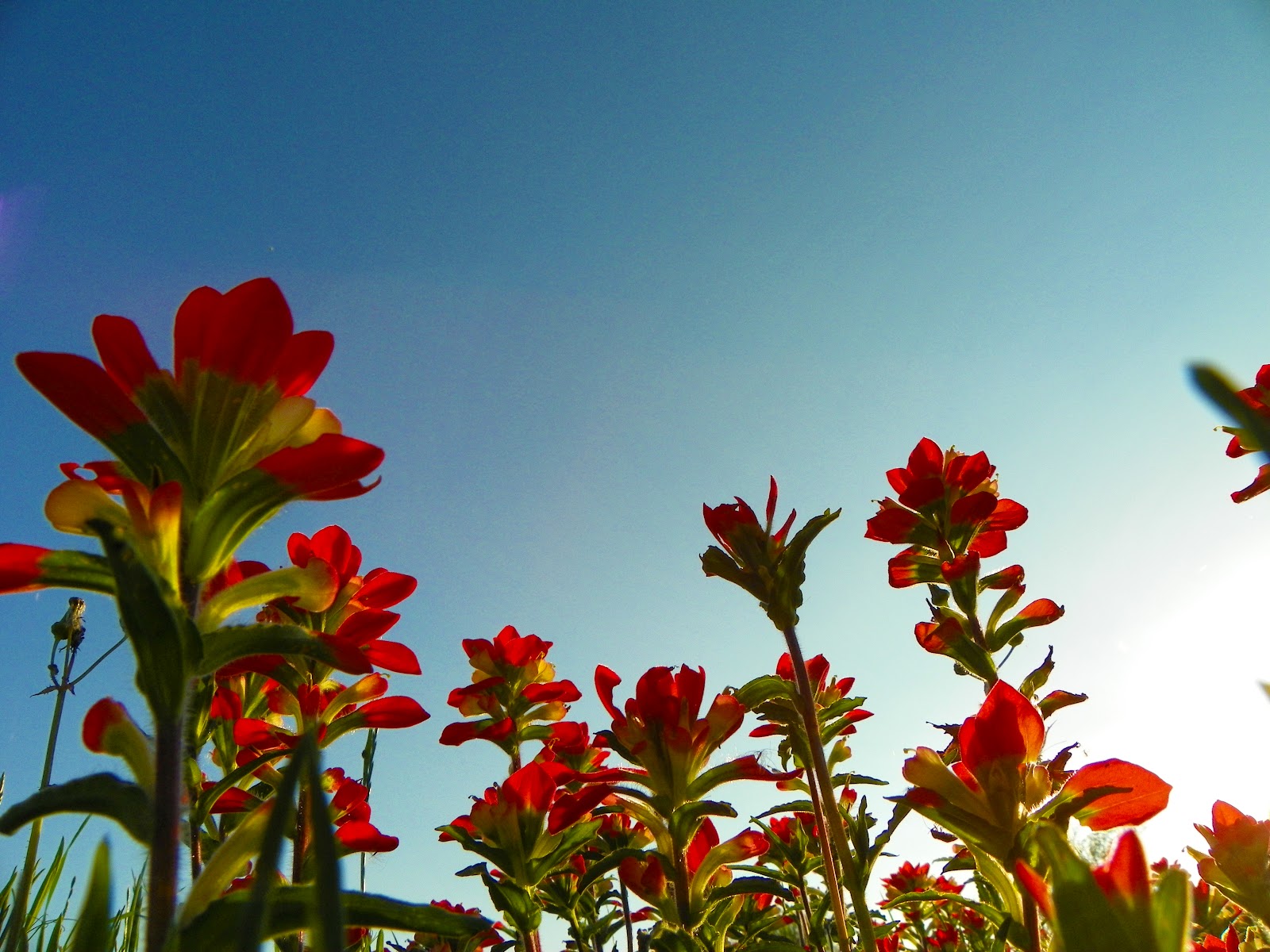
I planned on filling this post with photos featuring the bumper crop, maybe once in a lifetime crop of Foxglove Beardtongue growing along the cliffs. The showy 3 foot high plants respond in an exceptional manner to a prolonged drought followed by a wet winter. That enthusiasm gets diluted quite a bit when I see the river in a larger scope.

Purple Prairie Clover and Dewberries

Penstemon cobaea of the Great Trinity Forest


Foxglove overlooking the Trinity River
Members of the figwort family, these perennial flowers prefer the rocky cliffs limestone outcrops and near bear soil one can find on higher ground in the Great Trinity Forest. They go by Prairie Penstemon, Foxglove, Foxglove Beardtongue, Prairie Beardtongue  18-30 inches in height, these plants produce flowers up and down there stems in April through May. Since this spring was warm and wet, the flowers are earlier than normal. Actually, they are very prolific this year. Growing in places I have never seen them before.


Flowering yucca
Foxglove often share the same soil profile with flowering yucca and can be seen simultaneously this time of year at McCommas Bluff and the Scyene Overlook.

Also a banner year for pink evening primrose Oenothera  speciosa as seen below. Open fields are carpeted with them at the moment. Enough so that a walk or ride through them will leave you yellow with pollen


Pink Evening Primrose in the Great Trinity Forest


Lingering Effects Of The 2011 Texas Drought

McCommas Bluff Preserve is rarely visited and few if any people visit the secondary entrance to McCommas Bluff on Fairport Road. The preserve begins where Fairport dead ends. A recently constructed yellow gate blocks vehicle access to the woods. You need to either park and walk-in from there or make other plans. This was the proposed site of Trinity City. A long forgotten platted town in the Peter's Colony that hoped to serve as a port city on the Trinity River. It never happened. Over the last 150 years this piece of land had buildings, a couple post Civil War factories and an animal rendering plant.

The topography is a gentle slope, declining down towards the river. Borrow pits were dug in the 1800s to level the land off in a stair step set of terraces. This built up a profile of 100 yards of flat ground, followed by a descent and abandoned borrow pit, followed by more flat terrain. The borrow pit areas are now ponds during wet weather. To get a feel for this terrain, I have posted the video below which starts from the Fairport gate down to the river, then parallels the river for a distance downstream towards the cliffs at McCommas Bluff. Easy to access in drier weather from the Audubon Center too.


This upper portion of McCommas Bluff Preserve suffered heavily during the 2011 drought. Where most lowland areas in the Great Trinity Forest were buffered by damp soil, this particular upper terrace area saw many smaller trees die off. The photo of the pond above illustrates that well with a number of trees not coming back this spring. The pond went dry in late spring of 2011.


What In The Wide Wide World Of Sports Is A Goin' On Here?


Getting back to the construction. I gotta wonder. What is the method to the madness in all of this? The city says this marring of the landscape was needed to protect a 72 inch water main that runs down to the southeast waste water treatment facility in southeast Dallas county. Time was of the essence it seemed a year ago with potential erosion of the riverbank exposing the water main to problems. Fair enough. But the construction has been anything but fast and has eroded more riverbank than it has fixed. Not much has happened at all. Other than some large holes punched into McCommas Bluff large enough to drive a semi-truck through.


Much of this area was supposed to be protected as part of a US Army Corps of Engineers Mitigation Area. When the McCommas Bluff Landfill was expanded around 5-7 years ago, it ate up a good chunk of wetlands, forest and prairie. To mitigate that per a 2002 federal law, a special area was set aside and re-engineered for the purpose of the habitat loss......
As a reminder of where the area is located, a host of signs every 50 yards or so line the area that is not to be disturbed. The sign above is located near the Trinity River Trail and bridge(in the background). The Trinity River Audubon Center is about 1/3 of a mile from this sign on the other side of the river.

Below is the summary of the landfill application for the landfill extension describing the mitigation.

Fine and dandy till the 72 inch water main project started last summer. The idea is to rock armor the riverbank using chicken wire boxes filled with baseball sized pieces of concrete. Put enough chicken wire boxes filled with rocks together and you have a wall. The current construction, started last summer spans about 1000 feet of riverbank. Seen below, you can see the workers installing course after course of rock.

A wider view and you can see the large scope of the project. The workers and their equipment are at the very far end of the photo in the distance. Big project. Slow project. Takes a long time to do something this large. Going to be a long time before this wraps up.
Seems to me that the construction would finish a current project before starting on another. Last weekend I was puzzled to see that while construction had still not finished at the original site nor at the large holes chopped in McCommas Bluff, someone had taken the liberty of clearcutting another 1000 or 2000 feet of riverbank downstream.


The clearcutting extends from almost the new Trinity River Trail bridge down to McCommas Bluff. Strange thing is that this is in the Corps of Engineers Mitigation Area and some of the trees bulldozed were planted for compliance with the mitigation law. Some still have the green tarp material around the base of the trunk for irrigation. Puzzling.


If erosion control is the purpose here, why did they push so much of the bank and trees into the river? In some places doing this shed 4-5 horizontal feet off the bank.


Here you can see where the clear cutting stopped. What it looked like before in the background, versus what it looks like now in the foreground after the haircut. I'm sure there is a very logical reason for this. One above my brain level to comprehend. One that involves protection of the water main from erosion. Well...I got to thinking, has the river ever changed course through here? The solid limestone cliffs are just around the corner from here and serve as an effective barrier to any change in course. I also can see from this bend in the river, the original 100+ year old log moorings on the opposing bank for the riverboat landing used by excursion boats that took day trippers from downtown to the picnic grounds here. I pulled photos of the bend in the river from 1957 through 2011 posted below.

1957
1972

1989
2011

I'm just not seeing it. maybe it's my untrained eye. But I cannot see any difference in the bend now than the photos above. Oh wait. Yes I can. You see when they bulldozed off the bank, they took 4-5 feet of bank with it. Maybe a couple hundred years of erosion done in just one afternoon. Congrats!

I wonder if it would just be easier to just rebuild the whole pipeline? Seems that someone decided the river was the problem and the pipeline is the victim. I think it's the other way around. I don't want to see a concrete rock lined riverbank every time I cross that new million dollar bridge from the Audubon Center. If the pipeline was flawed in design, start over. It would be quicker to rebuild it farther away than fix a problem like this. The original project has seemed to lose its compass and over time with periodic flooding and maybe some sloppy on the job stuff accidents happen. Like this diesel fuel watery polluted mess.

Don't start new problems when you have not finished the old ones. I guess. Maybe I'm wrong here.


Wednesday, April 4, 2012

The Great Trinity Forest Trail -- What's Cookin' Down Yonder

Indian Paintbrush on Ancient Indian Campground Site In Great Trinity Forest April 1, 2012
The Comanche Legend of the Indian Paintbrush
"Little Gopher had a dream.  The vision told him to find a white buckskin and keep it.  One day he would paint a picture “that is as pure as the colors in the evening sky.” Although he found the buckskin, Little Gopher could not find the right colors. However, one night a voice told him to go on top of a hill the next day at sunset. The voice said, “Because you have been faithful to the People and to your true gift, you shall find the colors you are seeking.” The next evening, Little Gopher found paintbrushes the colors of the sunset all over the hill, and he painted his masterpiece. When he returned to his tribe, Little Gopher left the paintbrushes behind.The next morning the paintbrushes were all over the hills and had turned into beautiful flowers.  Little Gopher became known as “He-Who-Brought-the-Sunset-to-the-Earth.” --Comanche Nation


For most, the view gazing out over the Trinity River from the paved Buckeye Trail Overlook or Audubon Center Overlook would fulfill what they hoped to see when they visit. There it sits. Snap a photo. Foursquare it on Twitter. Leave. Mission complete. I would hazard a guess that 99% of the visitors to the Great Trinity Forest never venture beyond the established trails of the Buckeye and Audubon.

For a few others though, the question enters the mind, what's on the other side? What lies yonder. Most of the photos in my blog and places I mention are in the yonder and beyond yonder spots. They are the places left behind by nomadic tribes of wandering ancient people. They are the places left behind by the pioneers who tamed it. They are the places left behind after the cash crop of cotton, whose farmers wore out the soil. The places left behind by the quilt of random forgotten homes that pepper the river bottom bought by the city for flood easement.You see all of it combined as a mosaic on what the river is today. If you can find your way around. Which is tough.


Someone unfamiliar with the Great Trinity Forest will find themselves perplexed with the random ongoing construction that seems to plague the larger infrastructure projects that were slated for completion years ago. Along with other regular visitors, I have grown somewhat frustrated with the slow pace of some projects. It has created an uneven balance between completed projects grand in scope that sit marooned behind never ending public works projects. The bond money for these projects were allocated many years ago. It's the execution of the construction that is holding the works up.

Some of the concrete paths were completed in 2009 but lack a real purpose until they connect with the Audubon Center. It leaves you scratching your head. Wondering when and if. Life goes on though and for those familiar with the woods, the spring is the best time to visit with mid fall a close second.


For those willing to make the jump to the other side of the river, a new world opens up. One where the khaki bird watchers are left behind for spur wearing cowboys. The folks in the photos here are friends of mine, people I have gotten to know on the "other side" of the river from the Audubon Center. Really neat to see them together on a trail ride. Usually I see them in groups of two or three on weekend evenings. So to see literally everyone together is awesome. I think the riders in the photos represent half of all the people I have ever seen in the Great Trinity Forest on this side of the river. No one else really goes there.

Trail Riders in the Great Trinity Forest April 2012


Across the river from the Audubon Center
Bridge over the Trinity River to the Audubon Center


Miles from the nearest paved road in the Great Trinity Forest


The new multi-million dollar trail near the Audubon Center is finished on the north side of the river. So is the bridge. The hang up is a couple hundred yards of never ending construction on the south side of the river for a water utilities project.


Once completed the access to the south side of the river will really open up some true wilderness to those willing to cross the bridge. Deer and pigs run free here and are a common sight.


Map showing location in proximity to TRAC
Last summer when the bridge above was finished, I mentioned to the horse guys that they should ride over to the Audubon Center to introduce themselves to their new neighbors. They got dressed up and rode over on horseback. Unknown to them, the afternoon in question, the Audubon Center was hosting a runway fashion show. I'm not sure exactly what happened but they were received somewhat on the chilly side. The horse rider folks know all about the river and the wildlife. I know they would rather be a part rather than apart from all the signature projects across the river. Excellent resource, especially as bilingual guides,  if anyone bothers to ask them.


Along the new concrete path, which is what I guess will be called the Great Trinity Trail, remains of old farms are all but vanished. Left behind though are the spring Iris and other perennial bulbs that were once part of some farmer's front yard or garden. Like the one above at the old Truck Farm Trail site .


The trail and parallel access road sits close enough to the river and Lemmon Lake that animals cross it constantly. This large turtle above, a Common Snapping Turtle was on the trail in Mid-March. It looked like it was out to lay eggs. Weighing in well over thirty pounds+ this was a beast of a turtle. Many of these turtles resided nearby at Lemmon Lake until the 2011 drought dried up the lake bed. Turtles such as these became trapped in the deep mud unable to make the 150 yard journey to the Trinity River. With some help and a few shovels we dug many turtles this size out of the lake and put them in the river. I would bet this is one of those turtles.


The Great Trinity Forest Trail -- Through Joppa Preserve
Location and information 

Great Trinity Forest Trail Joppa Preserve April 2012


Somehow this concrete path has stayed off the radar since it was completed in 2009. Much of it was cut right out of very dense forest following a century old dirt path used by fish camp leaseholders at Lemmon Lake. Seeing little use, the forest is slowly reclaiming what was built just a couple years ago. A segment north of River Oaks Park even traverses over a swamp labeled the Otter Pond.

With just a couple hundred more yards of concrete construction this path will connect the Loop 12 Boat Ramp trailhead at Little Lemmon Lake with the Audubon Center.


Across From The Buckeye Trail -- The Trinity River Wetland Cells
Location and information


Trinity River Wetlands

This is the land that sits on the south bank of the Trinity River facing the Buckeye Overlook. During the winter it's possible to catch a glimpse or two of the lakes. The lakes are narrow and long cascading from one to the next in a chain stretching from I-45 to Loop 12.


In 2009, the area was sown with oats and rye grass which made for easy exploration of the hundreds of acres here. Later that summer, ragweed started to take over, making much of it impossible to wander in. By 2010 the ragweed was out of control, 8-10 feet high in many areas. In response, the Corps of Engineers is trying to rid this area of ragweed and converting it into a native grassland prairie. So far this year, 2012, it seems to be working. By mowing in 2010 and 2011 prior to the ragweed going to seed, the life cycle of the weeds has been dramatically curtailed. I hope! I use the dirt road and trails of the chain of lakes to make it on my trip down from White Rock Lake to the river. Jumping the guard rail at 310/Overton then down the lakes to Loop 12 and Joppa Preserve.

The chain of wetlands attracts more and more birds every year. Many that are rare for North Texas. A similar wetlands, the Bunker Sands Wetlands near Seagoville attracts bird watchers from all over. The chain of wetlands here in Dallas could be similar if more people knew about it. Same birds show up both places. Just a perception problem on the part of the people who visit.

Monday, March 26, 2012

Texas Wildflowers and Texas Wildpeople On The Trinity River

Texas Bluebonnets on the cliffs overlooking the Trinity River at McCommas Bluff
The Comanche Legend of the Bluebonnet

The Texas fields are covered
With a blanket of deep blue.
But for a little Indian girl,
This would not be true.

Texas land was buried and dry.
Rains just would not come.
Indians danced and prayed for rain,
And beat upon their drums.

The Chief made a proclamation.
He appealed to one and all.
A prized possession must be sacrificed
Before the rains would fall.

The Indian camp was silent,
While each person searched his heart.
But when it came to sacrifice,
With possessions they would not part.

Suddenly a little girl stepped forth,
Holding her blue-clad doll.
She placed it in the roaring fire
and raindrops began to fall.

The rain brought forth the grass,
Among its blades, flowers of blue.
To be a sign for all the time
Of a love so pure and true.


That old Comanche parable rings as true today as it did dozens of generations ago when the Comanche told it around their campfire. Drought and flood, famine and feast is natural to Texas. With higher than average winter rains the bounty of wildflowers this year along the Trinity River in the Great Trinity Forest is the best I have ever seen. Despite the forecasts of a drier and colder winter the DFW area saw one that was warm and wet. Thus set the stage for an early spring. The heavy rains and regular flooding of the lower areas in the Great Trinity Forest have re-directed much of my mountain biking into the upland areas that are not prone to prolonged flooding. I've never messed around with the macro settings on my camera since I usually only stop to photograph things with four legs. The muddy conditions gave me a chance to stop and smell the roses for once. The photos in this post were taken over the weekend of March 24th-25th and highlight the Lower White Rock Creek Trail, McCommas Bluff Preserve and the Texas Buckeye Trail.


McCommas Bluff Preserve
Location and information McCommas Bluff Preserve Trails


McCommas Bluff has seen its share of hardship the past year with the city demolishing some of the historic trademark cliffs. Upstream some of it still stands untouched as the river begins a gentle bend to the west towards the Audubon Center.


Among the terraces of McCommas Bluff on the old Trinity City ghost town site, a meadow of poppies grow


Grey Hairstreak Strymon melinus on Texas Bluebonnet Flower McCommas Bluff Preserve


Sometimes I pat myself on the back thinking about how cool it is to be the only person seeing this stuff and realizing how lucky I am to experience things no one else will. I was having one of those pat myself on the back moments when in the far distance down river I heard boat motors. Up the river come two guys at thirty miles an hour on jet skis! Man. Talk about raising awesome bar to a new level. Below is video I shot of them headed up river. Only in Texas!


Donned in wetsuits and goggles, they were taking advantage of the Trinity River in flood stage. That evening, the river was still in flood, about 12 feet higher than normal. This allowed them to navigate over the McCommas Bluff Lock and Dam #1 without issue. During normal water levels, this would not be navigable to small boats or even canoes.

That is some real out of the box brainstorming to pull off something that awesome. A place to launch or recover watercraft is miles away in any direction. Very difficult conditions if something goes wrong. Logs the size of couches, whole tree trunks and even floating ant balls went cruising by in the current. The amount of skill it takes to ride up the river, the Trinity River, takes a lot of nerve. It's interesting that I keep on running across people like this down there. I know people, friends of mine, who go to the Amazon to find adventure like that. It's in their own backyard. This place is a ten minute drive for a million people.

Chapel at McCommas Bluff


Piedmont Ridge Trail
Location and information Piedmont Ridge Trail


The Piedmont Ridge Trail sits on a high chalk escarpment overlooking White Rock Creek between Grover Keeton Golf Course and Bruton Road. The trail climbs up some switchbacks to the top of the ridge. This trail is usually combined with the Scyene and Devon Anderson Trails since they all link together. I believe this flowering shrub which is blooming everywhere along the trail is Texas Torchwood. I could be wrong.


Piedmont Ridge Overlook with view of Downtown Dallas


Comanche Nation Sacred Storytelling Place


Anchoring the south end of the Devon Anderson Trail is the Comanche Storytelling Place. Shaped like an amphitheater, the natural limestone rock bowl was recognized by the Comanche Nation in 1997 as a sacred spot to their people.


Within 100 feet or so west of the Storytelling Place is the Storytelling Place Red Oak. Listed in the DFW Tree Registry as holding not just historic status but also one of age. It grows on near bare limestone and while only 25 feet tall has a massive trunk base. Estimated at hundreds of years old, it is probably one of the oldest trees in Dallas. Nice to see these bare soil trees to pull through last years drought.

Storytelling Place Red Oak


Pink Bluebonnets At Scyene Overlook


Pink Bluebonnets at Scyene Overlook

Like the Comanche, Texans have their own legend about a bluebonnet, the Pink Bluebonnet. Only place I have ever seen these growing in a native environment is at Scyene Overlook.

Texas A&M's website has the legend of the blood spilled of the Alamo Defenders upon white bluebonnets that now give them their unique pink color Legend of the Texas Pink Bluebonnet


These pink bluebonnets are located in very poor soil downslope of the Scyene Overlook, on the south and southwest facing slopes.


Flowering Texas Buckeye Trees
Location and Information Texas Buckeye Trail William Blair Park

Tiger Swallowtail at Texas Buckeye Grove in Great Trinity Forest March 25, 2012
Rounding out a look at the early flowering plants of the Great Trinity Forest is a very wet, very muddy jaunt down the Texas Buckeye Trail to the Buckeye Grove. I second guessed myself a couple times as I waded through a mile of shin deep water and mosquitoes to the grove. I was rewarded with what you see in the photos. A large Tiger Swallowtail feeding on the sole remaining Buckeye Tree flower.

Tiger Swallowtail (Papilio glaucus)