Friday, February 22, 2013

Bike Rafting The Trinity River and Mountain Biking The Great Trinity Forest

Bikerafting through the Trinity River Standing Wave Whitewater Upper Canoe Bypass in Dallas, Texas
Our specially crafted boats, by design, should have been somewhere north cutting a wake on the Arctic Sea Ice or carrying a field dressed moose across an Alaskan fjord. The weather was cold enough. The whitewater rapids strong. A pair of Bald Eagles, the distant noon howl of coyotes and Northern Shoveler ducks by the thousand to keep us company. An Alaskan adventure in every since of the word. I'm sure four months from now those same eagles and ducks will most likely be in the land of the Canadian midnight sun. But not this day. It was mid-February. In Texas. The only thing resembling ice was spelled out on the Katy Trail Ice House marquee where this trip started and finished.

Trinity River Standing Wave Sketch circa 1998 (City of Dallas)
Five years ago, the sights, sounds and place names in this post did not exist. They were blueprints, sketches and dreams of benchmarks yet to be realized. The foundations of the Trinity River Corridor now affords those with some creative outside-of-the-box ideas and a sense of adventure to do things really unique on a Saturday morning. Labeled boondock country by many, wrongfully mired in political debate, the true nature of the river becomes difficult to conceive as a whole.

The Trinity River Project could be seen as a blank slate yet to make a mark on the city that surrounds it. There seems to be a fundamental misunderstanding about how many of these projects can be woven together into a twenty mile journey up and down the Trinity River. Limited only by your own imagination there are ample opprotunities for adventure. It's fun to see these renderings come to life, whether they are a signature bridge, a bike path, nature center or whitewater park.

Evan and Will of Big City Bike Rafts
Two such pioneers literally testing the waters of the Trinity River are Will and Evan, two Dallas residents who bike raft rivers around the Southwestern United States. Together they formed Big City Bike Rafts that will rent you an Alpacka raft for a modest fee. Will mentioned that they bought the rafts after a long search for a Trinity trip last summer. They had to source the raft rentals from Jackson Hole and Salt Lake City at great expense and trouble. Bitten by the bike rafting bug and not wanting to go through the expense of mail order renting they purchased a set of rafts. Will and Evan shot me an email earlier in the winter about a float/ride through the Great Trinity Forest and I jumped at the chance.


The Equipment

At first glance one might see inflatable boats as a mediocre way to travel on water. These are no ordinary boats. Built by Alpacka Raft in Mancos, CO, they are the preferred choice for many cross country adventure travelers. Weighing in at five pounds and rolling up to dimensions the size of a loaf of bread, they allow for real flexibility in travel. Jonathan Waterman, author of the book published by National Geographic Running Dry: A Journey From Source to Sea Down the Colorado River used an Alpacka on his 1450 mile journey from the source of the Colorado River on the snowpack in Colorado's Rocky Mountain National Park all the way through Arizona's Grand Canyon and down to Mexico's Baja. Impressive boats with a load capacity in excess of 350 pounds and good steering manners.
Will giving a demo on assembling the raft
They assemble and inflate in about five minutes using a unique pillowcase style bellow rather an a traditional pump. Simply grab some thin air then run your closed hand down the length of the blue bellow, pictured left at the Dallas Standing Wave Portage Ramp. Rated for Class III intermediate rapids, the finesse issue of the handling lies more in getting your load balanced and center of gravity low.

The boats don't carry through with as much of a gliding coast like a canoe but make up for it with added maneuverability and less draft it seems.


 The Route Downriver-- Katy Trail Ice House to the Audubon Center

There must be thousands of people who use the Katy Trail on a Saturday. Few venture far off it. The trail itself serves as a great avenue for reaching other parts of Dallas. The Arts District, the American Airlines Center, the Audubon Center! Originally the MKT railroad, the old line cuts a bee-line right to the old river channel.

Above is the Google Map Route for the trip down the river starting at the Katy Trail Icehouse and heading south across the Continental Street Viaduct. The return trip was similar and can be found further down in the post. For those that keep score with their GPS, I believe Will of Big City Bike Rafts holds the Strava KOM for the route.
Relevant benchmark mileage points:
5.5 miles from the Katy Trail Ice house to the Trinity River Standing Wave.
6.2 miles down river from Standing Wave to Loop 12. 11.8 total miles from Ice House to Loop 12
4.7 miles from loop 12 to the Audubon Center. 16.5 miles total from Ice House to Audubon Center.

On walls that once housed the Italian Restaurant Cremona are chalkboards that line the exterior. Entitled "Before I Die I Want To.." the chicken scratched scribble of strangers profess things they always plan on doing but might not get around to in this lifetime. We were set on ours.........


 ....and that's where our trip began on a cool, serene saturday morning. In stark contrast not twenty five minutes later we were wet and in a washing machine of Class II-Class III rated whitewater.


Getting to the river is a snap. Down Continental and across the bridge one can be on the levee perimeter road in mere minutes. Open year round to non-motorized traffic the levee road is slowly becoming known as a great training ground for off-road cyclists and running groups looking for softer surface training.

Trinity River Levee Perimeter Road with the Margaret Hunt Hill Bridge in the background
Currently the only paved stretch of trail is a short section of path from the east side of the I-35 bridge to the west side Santa Fe Trestle Trail on the Oak Cliff bank of the Trinity.

Assembling rafts and disassembling bikes
29er mountain bikes are quickly gaining in popularity and outselling traditional smaller wheeled 26 inch mountain bikes in many stores. For this trip we all rode 29ers which suit themselves well to North Texas trails. Disassembling the bikes and mounting the larger wheeled bikes on the rafts was a snap. The boats have straps and attachment points similar to the old clipped pedal cages of pre-SPD style pedals. By design the teeth of the clasps hold strong even when wet and the webbed material will not stretch.

The Dallas Wave -- Running the Trinity River Project's Standing Wave

 
Launching from the Portage Ramp and approaching the Standing Wave

The scrawny meandering wooded stream known to many as the Trinity River does not exist in the first one hundred yards downstream of the Santa Fe Trestle Trail. Here a canoe portage ramp exists serving as a bookend of where the Trinity River levee floodway ends and the untamed wild river begins. Whitewater.
Video summary of the trip, including negotiating the Standing Wave
June 2010
Construction began on the Standing Wave in the summer of 2010. Using a diversion channel the Trinity River was temporarily moved to the north allowing for foundation work in the riverbed.
August 2010
By Christmas of 2010 the Standing Wave was complete. Below is how the Standing Wave looked just prior to the Trinity River being placed back into the original channel.

December 2010

Taking the purpose built canoe bypass on the Standing Wave Project
The approach to the Standing Wave is uneventful the roar of the rapids beyond cannot be heard until reaching the lip of the feature itself. We decided to take the River Left canoe bypasses, a pair of which allow for a somewhat calmer traverse of the whitewater.

Upper Wave slackwater area of the Trinity River Standing Wave
Above is the slack water Upper Wave play area. The hydraulics of the water seem to move counterclockwise in the upper pool, gently swirling around.

Negotiating the Lower Canoe Bypass
The Lower Canoe Bypass has a considerable drop to it, much more than the Upper Bypass. Seen above, the water has a faster speed, longer drop and more run out. I recall that attempts have been made to fix this problematic spot, placing a large boulder near the lip of the bypass to curtail the flow, reworking some of the funnel. Where the Upper Bypass is a piece of cake, I think that a larger boat like a canoe might think twice about negotiating the Lower Bypass. Portaging might be a better option.
Lower Standing Wave looking upstream Corinth Street Viaduct in far background
The Lower Standing Wave is an easier piece of water to dabble in. This particular day the water was a modest 700 CFS which would be considered an average flow year round. In the summer it drops off to 450-500 CFS during dry spells.

Beyond is the scenery of which Dallas can now boast, the sort of natural areas that people just don't see on their way down I-45 to Houston.

The Journey Downriver
Approaching the Cedar Crest Bridge

The Cedar Crest Bridge is the first bridge on the float one reaches about 1/3 of a mile downstream of the Santa Fe Trestle Trail. Soon, the Corps of Engineers will radically alter the woods here, removing most of the trees to build wetland cells. It has already begun to some extent with the removal of a forested area on the southwest side of the bridge. Hope they know what they are doing!

MKT Trestle circa 1905

Hey, it's the Katy again. The next bridge up is rumored to be one of the oldest railroad bridges still in use that spans the Trinity, the MKT railroad bridge. Hidden from any street view one can only see it from the river. Interesting old bridge, the random train horns from locomotives crossing here keep South Dallas residents up at night.

Some of the more detailed history and backstory of this stretch of river can be found in a previous post from November on a canoe trip with a historian, wildlife expert, two master naturalists and a pig blood drone pilot Exploring the Trinity By Canoe.

Beyond the railroad trestle, the river exhibits a cross section of the sediments that underlie the Blackland Prairie plains, an apron of gravel debris laid down anciently by immense rivers coursing out of the mountain west when those peaks were young and high. Behind the old Procter and Gamble Plant the gravels here point to a much older time.

Miller's Ferry
Historic Miller's Ferry Site
William B. Miller
 Miller's Ferry has been used for centuries by man as a way station on the Trinity River. This trip we used it to stretch our legs as the halfway point of our float. Nestled between the elevated I-45 and Highway 310 bridges it serves a great rest stop. Despite the heavy rains of the previous week, the ground was slippery but firm.

The namesake of the crossing is William B. Miller an early Dallas pioneer who made a lasting mark on much of Dallas as a whole. An enterprising businessman on the south bank of the Trinity, he needed a ferry crossing to reach Dallas. In turn, Dallas needed a reliable ferry crossing to reach Hutchins, Corsicana and points south. Miller's Ferry road still exists today in southern Dallas County and served as the piggybacked route for the first railroad, first highway and first interstate into Dallas.

The debris and scree today at Miller's Ferry look like a standard mess of old rusted construction but in reality are the remains of bridges and crossings past. In the photo above, the concrete casements, iron shrouded piling and cable pieces are legacies of old times gone by. The first ferry was hand pulled, similar to the one seen inset left. During low water, the cottonwood built ferry sat in the mud and served as a low bridge. During high water the bridge was pulled via rope and braided cables. It's believed that the "cut" in the bank(where we parked our boats in the photo) at Miller's Ferry, shown as a historical feature most likely was part of that old site.

Millermore Mansion in Old City Park
Miller's antebellum style mansion, Millermore was moved to Old City Park near Downtown Dallas where it stands today. There is much more history to the ferry site which can be found in more detail in a previous post 3000 years of history at Miller's Ferry .

 Through Rochester Park and up White Rock Creek
Navigating the mouth of White Rock Creek, looking upstream
Remote canoeists camp on White Rock Creek
 A distant howling chorus of coyotes greeted us as we floated past the Buckeye Grove in Rochester Park now known as William Blair Park. Eerily calling a noon howl from afar the true wilderness of the river made it's mark. Below the Buckeye Grove sits the mouth of White Rock Creek which is usually hard to travel due to snags. This day the flow and level of the creek was higher allowing for further travel upstream.

The sheltered creek mouth here makes for an excellent stop and makes for an excellent overnight canoe camp spot on the river, high and away from the bank.

Downstream to the east of the river we floated past what will soon become the Trinity Forest Golf Course. The tall pecans, walnuts and oaks that line the banks here will most likely hide the course from the river. Once an old gravel mining area, this parcel of land yields some of the finest fossilized animals in the United States. The old gravels mentioned earlier in this post served as a vast sandy marsh when mammoths roamed Dallas. The new Perot Museum of Nature and Science in Dallas features a mammoth pulled from this very spot, soon to be a golf course.


Take Out at Loop 12
We took out at the Loop 12 Boat Ramp where the Trinity River Trailhead begins and travels through Joppa Preserve on a 4 mile paved path that loops around to the Trinity River Audubon Center. From here it's all bikes. Dismantling and packing boats and assembling bikes on a jaunt down the river to the Audubon Center.

Trinity River Trail Bike Path Bridge Over The Trinity River
The multi-million dollar bridge here has been completed for at least a year. Final completion of the trail was held up due to a Water Utilities project of riverbank stabilization. The trail skirts the Audubon property with a new solar powered trailhead near the Audubon Center entrance.

Trinity Trailhead on the Audubon Center entrance way
This lot as well as the Audubon Center itself will serve as a great jumping off point to exploring the Great Trinity Forest in the future. I think there are still some wrinkles to be ironed out in regards to using this particular trailhead when the Audubon Center is not open. I had a conversation with Don Burns, the Trinity River Project Manager last week who explained that new interior gates were in place for the Audubon Center drive to accommodate trail users.

Speaking of the Audubon Center, we were met by Ben Jones the director of the Audubon Center and a staff member in the center's breezeway.  Will and Evan's photo made the Audubon Center's blog:
http://trinityriveraudubon.tumblr.com/post/43272339659/great-backyard-bird-count-2013-over-30-unique

Ben Jones mentioned that this day in particular was a peak day for the annual hawk migration and it clicked with us since we had seen so many hawks while on the river. The final count of hawks for our party was in the ballpark of two dozen hawks and two Bald Eagles, one mature adult and one juvenile.
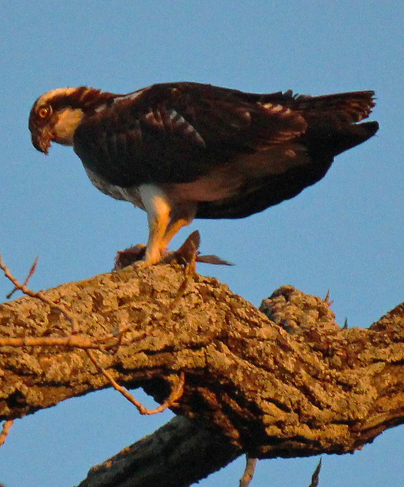
Red-Tailed Hawk near Miller's Ferry on the Trinity River
The hawks we saw that day were moving through just like we were. On the way to somewhere else. Most had rather inquisitive eyes and allowed us to get quite close and in many cases just stayed on perch rather than take flight.


Return Route

Google Map Route Return Route Above is the return route used in the trip. Utilizing the Trinity River Trail from the Audubon Center to Loop 12. The next section follows the crude doubletrack of the Wetland Cells abutting the Freedman's community of Joppa to Highway 310 at Miller's Ferry. Crossing the bridge and taking South Lamar through the Bon-Ton, Cedars and eventually Downtown Dallas back to the Katy Trail.

14 miles, one way. If someone wished to ride mountain bikes, a cyclocross bike or even a beach cruiser from Uptown or Downtown to the Audubon Center this is the very best route to take. We took this route back to make it as clear and concise as possible for anyone else wishing to replicate the route. Naturally, there are many other side routes, detours and trails one can take off this route. I think one will find that the generosity, friendliness, in its width and scope among the people there is unique to Dallas. It is good-people country.

Wetland Cells
Evan riding the Wetland Cells approaching Highway 310/Lamar
Riding back was quite simple. Up the bike path towards Loop 12, then across Loop 12 to the Wetland Cells. Here we followed a simple set of doubletrack dirt road that loosely follows the chain of wetland cells up towards I-45. One can ride as far as I-45 at Overton. Since we were on bikes, we vacated the river at 310@Overton. Here the highway bridge affords a wide shoulder and low vehicle traffic. Often crossed on foot, bike and horse by area residents, it's a good bridge to cross for our purposes.
Lamar Street under the Dallas Convention Center
Up South Lamar and only minutes later we are riding into Downtown Dallas. On the ride back, people become part of the landscape. The liquor store lot Day Drinkers along South Lamar. The vagabonds pushing shopping carts full of things others have built, destroyed or thrown away. The newly minted parolees stepping out of the Greyhound Bus Station. The tourists of the West End wearing sweatshirts of distant colleges unknown in these parts. Ten minutes is all it takes on Lamar to go from the poorest of the poor to the richest of the rich. An interesting slice of humanity.

Lamar has become newly marked in late 2012 and early 2013 with shared bike lane symbols from the Convention Center to the Katy Trail. We used the marked lanes on our ride past John Neely Bryan's cabin site in the distance and through Victory Park back to the Katy Trail. Great adventure. One you can take too.

Seems that much of this kind of thing is new to Dallas and still lacks an anchor point for exploring down the river. The next few months are the very best time to visit the Great Trinity Forest. 

New projects like Dallas County's Gateway Park seen below at Dowdy Ferry and I-20 will open up river access to the far reaches of Dallas this spring. The large fishing piers, horse trailer parking and trails will open up a large part of the Great Trinity Forest that few have ever seen. Gateway Park will connect with the Trinity Trail near Audubon Center within the next year.

For those seeking high adventure, rolling your own way and no hand holding, the Great Trinity Forest and the Trinity River itself serve as a great venue to really push your limits. It continues to amaze me that more people do not get down here and explore. On this fine Saturday,  other than the sole fisherman who drowns worms at the wastewater treatment plant outlet and a guy with a stuck 4x4 in the Wetland Cells, we saw ZERO people. Amazing.

Dallas County Gateway Park at Dowdy Ferry and I-20
A special thanks once again to Will and Evan. Best of luck on their new venture and new adventures exploring rivers abroad!

Thursday, January 24, 2013

Eagles in Dallas County's Trinity River Basin

Somewhere beyond the remains of an old brick factory and the town that carries the same name lies a unique corner of Dallas County where the Trinity River and tributaries engage in wholesale misanthropy against a population hellbent on controlling it. The give and take struggle, man vs nature, has yielded an out of sorts landscape primed for the largest hunters of the North American skies. Eagles.
The twilight evening moon setting behind an Osprey (fish eagle) in the floodplains of Dallas, Texas January 2013

The modest world of topographical study does not lend itself well to the open prairie of North Texas. Attempts at flattering comparisons to that of the Texas Trans-Pecos or rolling Hill Country fall flatter than the land itself. Most of what made this land so special to pioneers, why they settled here instead of the rough hewn rolling cedar hills further west is an answer lost to most. The grand prairie grass plains.

Restored Tall Grass Prairie in Southeast Dallas County near the mouth of Ten Mile Creek and the Trinity River
There was a time not long ago when settlers to North Texas would send letters back east proclaiming the vast shoulder high grasses that extended as far as the eye could see. The Indian, buffalo, grama, big and little bluestems, names forgotten to most. That epic carpet of grass, has long since been subdivided, housed and paved over. Remnants still exist. Patchwork quilted along old railroad sidings, vacant lots and forgotten farm family cemeteries. You don't get a feel for it though. The ocean of grass moving like waves on water. The aesthetics of a fast moving red lit sunset moving across a field so fast you cannot keep pace. Here, you can experience that. This panoramic view attracts more than the wandering human eye but also that of winged predators who feast on the rich fields of quarry that these fields invite.

Ten Mile Creek valley overlooking the South Creek Ranch's Red Angus herd with Riverbend Preserve in the far treeline beyond. Dallas County Texas.
In order to see such a sight, one of large tract native grass vistas, one needs to head into the farthest corner of Dallas County. It's a great place few know exist. It's not on the way to anywhere. It serves as no shortcut. The roads can become impassable after heavy rains. I offer this area as one of the best to see eagles this winter inside Dallas County.

While the eagles featured in this post were often photographed inside the city limits of Dallas and inside the confines of Loop 12, the more remote areas of Southeast Dallas County afford the best chance to see one. Parkinson and Wolf Springs Roads seem to be the best option if one wishes to keep your sightings a car bound affair. For the more adventure seeking, one of the least visited Dallas County nature preserves sits right in the middle of this eagle rich countryside. A few months ago, Chris Jackson made a detailed report of his trip to the preserve and Lock and Dam #4. He has spotted numerous bald eagles inside the metroplex this winter including some around the south side of the Lewisville Lake Dam.

Dallas/Ellis County line on Wolf Springs Road looking south into Ellis County. Dallas County portion is paved and abruptly ends at the county line. Trinity River is in treeline to the left, old Ten Mile Creek Channel is immediate right of photo
This area in Southeast Dallas County is literally a place where the pavement ends. This is one of the only places I know of in Dallas County where you can literally see a mile in any direction and literally sit in the middle of the road if the mood strikes without worry of being run over. The silence is deafening on windless visits here. Beyond lies the unkempt roads of rural Ellis County and roads aptly named after places they once served. Sawmill. Log Ranch. Trinity Basin. Ten Mile.

River bottoms such as these are prime real estate in the winter for large birds of prey, the largest seen in Texas are eagles.The Trinity is often overlooked for eagles. The Colorado and Brazos to the south steal the thunder of North Texas when it boils down to the grit.

Why Southeast Dallas County Attracts Eagles
Current Bird's Eye View of Ten Mile Creek where it enters the Trinity River north of Wolf Springs Road in Dallas County


1900 Map showing Ten Mile prior to channelization
For millennia a quiet war of wills has raged down here between the land and the river that cuts through it. From the north the river has hauled down tons of silt many times over and deposited them annually on these fields. The near biblical floods of pre-history have changed the course of the river and tributaries here often. The long forgotten riverbeds go by new names, Cottonwood Slough to the west and Parson's Slough to the east.

USGS India Quadrangle noting old Ten Mile Creek Streambed
Man has changed the streams here too. The rich flood prone land impeded farming in the early parts of the last century. Efforts were made around the First World War to reclaim some of this land and put it into production without worry of seasonal flooding.

2012 aerial view of Wolf Springs Road with old Ten Mile streambed visible
This was one of the earliest forays of Dallas County into rechanneling a stream. At top right the Dallas County Map of 1900 shows Ten Mile Creek headed south into Ellis County where it reached the Trinity some distance below the county line. The circa 1917-1920 public works project moved the mouth far to the north well inside Dallas County on an east-west path. A series of small levees were built in this area which contributed to flood protection.

It's worth noting this century old project because the wildlife still seem to congregate along the old creek channels. This shift of streams greatly plays an integral role in the sheer numbers of animals in the area.

Smaller tributaries such as Bear Creek were also moved as a result of this project and funneled south to join Red Oak Creek near it's mouth with the Trinity River.


The Crested Caracara --The Sacred Eagle of the Aztec

Crested Caracara beginning a gliding dive over Ten Mile Creek


Crested Caracara hunting over Ten Mile Creek near the Trinity River

Aztec Warriors as depicted in the Florentine Codex
Here among the patchworked squares of Ten Mile Creek bottom works one of the most revered and mythic eagles of North America, the Crested Caracara (Caracara cheriway).

The Caracara has long been a sacred bird for the people of Mexico. Steeped in deep legends of the Aztecs of interior Mexico, the sighting of one had deep significance. The symbol of the Caracara is immortalized in the petroglyphs of Aztec pyramids across the region.

The most fearsome of Aztec shock troops the Eagle and Jaguar Warriors wore suits fashioned from the feathers of the Caracara. Called the cuāuhocēlōtl these soldiers were the most disciplined and during the Spanish Conquests of Mexico could fight the well armored Conquistadors on an even field.

Crested Caracara hunting a field near Ten Mile Creek
The Caracara is now represented on the national flag of Mexico. Some liberties have been taken with the coloration to reflect the appearance of a Golden Eagle. The story goes that the Aztecs in 1325 AD received a vision or a sign through one of their many gods that told them they would know where to build their central city, the empire  of Tenochtitlan when they saw what is today depicted on the Mexican Flag. They were told that when they saw an Eagle perched on a Nopal cactus with a serpent in its talon, located on an island, this is where they should begin to build their permanent city. They supposedly did encounter this on an island in the middle of a lake (Lake Anahuac) now known today as Mexico City.
Caracara with a snake in beak

I find this story relevant because the Caracara seen in Dallas County hunting over the sunny but cool fields of Ten Mile Creek came up with a snake as a late afternoon meal. Seen pictured at right. This is most likely one of a mated pair that loiters up and down the river in this area over the last few winters with regular frequency.

These birds have the body and span of an eagle but tend to forage more on a wide array of carrion if the opportunity presents itself. It would be fair to say that the have the body of an eagle and the mind of the most depraved vulture. I have seen Caracara as far north as the old Progreso Farm location on Pemberton Hill Road in 2009-2010. The area was strewn with discarded animal remains at the time from a slaughterhouse operation. As a result the area was thick with carrion loving birds.

Caracara are actually listed as a Threatened Species under the Endangered Species Act. Much like the Wood Stork that ranges through this Dallas countryside in the summer months, the habitat threatened Caracara is listed not for the ranging birds from Mexico but those residing in Florida. At some point in the past a vast extinction event took place along the Gulf Coast between Florida and Texas separating the populations into two distinct groups. The Endangered Species Act contradicts itself in a few areas regarding species protection. Rather than separate the population into subsets, the species as a whole is protected.


Caracara are a somewhat rare sight in Dallas County. They are most often seen around landfills in Irving, Dallas, Mansfield. North of the DFW metro area they are very seldom seen. Maybe in coming years as this species population improves more will be seen towards the Red River.


The Bald Eagle -- The Trinity River Duck Hunters

Ducks in flight over the Trinity River Wetland Cells
In a woodsy corner of Pleasant Grove the ducks stack up in mid-winter thicker than a traffic jam on Central. Safety in numbers from feathered foes loitering above waiting to pounce for an easy breakfast.

Juvenile Bald Eagle (Haliaeetus leucocephalus) in the Great Trinity Forest near the confluence of White Rock Creek and the Trinity River, Pemberton Hill, Dallas Texas, January 19, 2013
I chalk up the drought of 2011 for a less than productive year of eagle sightings in the Great Trinity Forest. The scant food and dried pocket ponds caused many of the wintering waterfowl to head further south to the coast. With the ducks went many of the eagles who follow like lions stalking a wildebeest migration.

Bald Eagles are rather punctual as a breed. Give or take a week they always seem to show up about when expected. It was disappointing not to see them last winter. The ebb and flow of winged wildlife is only tied to food sources and weather. Both in short supply last winter. A near normal spring and summer yielded more food and shelter this winter holding the ducks here in Dallas for a longer period.
Adult Bald Eagle (Haliaeetus leucocephalus) near the mouth of Ten Mile Creek and the Trinity River, Riverbend Preserve, Dallas County Texas, January 13, 2013

Inside the city limits of Dallas eagles are seen much less frequently. Casual documented observations have been made at White Rock Lake in years past but they are very infrequent and the birds seldom stay long. The photos above show two common adaptations of Bald Eagles. The juvenile Bald Eagle was seen in the Pemberton Hill area on January 19, 2013. As is customary these oddball sightings always seem to involve Bill Holston a Master Naturalist and all around master hiker to boot. I being armed with a camera and he armed with binoculars, we both scratched our heads about the odd looking juvenile bird. It was not until a look through the images post hike I was able to see it was a Bald Eagle. It might have fooled us humans but the ducks pecking away at morning breakfast in the pond ahead of us knew what it was...........
Ducks in a flooded Pleasant Grove field near the Trinity River, scattering at the sight of a juvenile Bald Eagle
....like a Chinese fire drill.

It can take years for a Bald Eagle to develop the hallmark white head. Seen in a photo above, that particular adult Bald Eagle was seen down near Ten Mile Creek, a healthy distance away over a grove of large trees. The great majority of the Bald Eagles in this area are merely transients and are not building nests in the Dallas area. The Great Trinity Forest has a very few scant trees that would even be capable of Bald Eagle nest habitat. The eagles seen in Dallas proper most likely commute from larger bodies of water like Ray Hubbard, Tawakoni and Richland Chambers where eagles reside in greater numbers during the winter.


Great Horned Owl
The Great Trinity Forest and White Rock Creek drainage does make for excellent owl habitat. Wearing a coat of natural bark camouflage Barred Owls and Great Horned Owls are a worthwhile pursuit within a half hour of sundown in the woods here. No special equipment is needed. Just a sharp set of eyes and the patience to find them.


Barred Owl near the Buckeye Grove


Osprey -- Fish Eagle of the floodplain

Osprey (Fish Eagle) feasting of a freshly caught carp in Dallas Texas under a rising moon

Fog rising among White Rock Creek's five story tall trees in the Great Trinity Forest, Rochester Park
The Osprey and owls are the only raptors whose outer toe is reversible, allowing them to grasp their prey with two toes in front and two behind. Known as fish eagles, sea hawks and fish hawks the Osprey(Pandion haliaetus) is one of the great winged aquatic hunters of North America. The special talons allow the osprey to firmly hold onto slippery fish which makes up the primary source of food in the diet.

This particular species of bird is often seen diving head first towards water then using razor sharp talons to deliver a devastating blow.

Widespread across the globe, these birds live on every continent but Antarctica.
Osprey clutching a carp on a cottonwood tree
Suffering a similar fate of the Bald Eagle, the widespread use of the pesticide DDT had negative impacts on the Osprey population in the last century. Due to the widespread geography of the Osprey the overall health of the species was maintained during the use of that chemical. The numbers are now up higher than before and the Osprey is becoming a more familiar sight far into the plains of Texas.

The Osprey in these photographs is an infrequent visitor along the White Rock Creek drainage. Being a unique bird to the area it's unknown whether or not similar sightings this past fall of an Osprey near the mouth of White Rock Creek are the same bird.


Much of the wildlife habitat in this thread exists not through preservation of habitat but rather private conservation efforts by places like the South Creek Ranch. Proper rural land stewardship and not overworking the land has provided not only for excellent grazing and agriculture. It has dramatically increased the diversity of species that were for all practical purposes once hunted or driven to extinction inside Dallas County.

It seems that without reservation that the Trinity River Project faces problems far greater than most people realize. The mismanagement of this resource across a broad scale is starting to impact the natural wildlife that is just starting to make a toe hold back into the woods. No amount of money can create some of the sights down there. But for a price, you can destroy it.